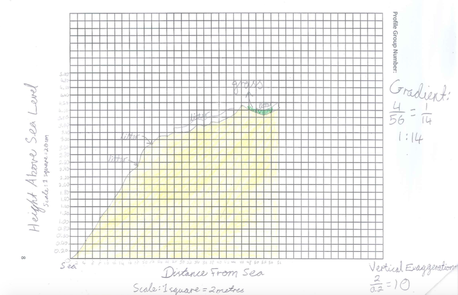
Beach Profiles and Analysis
The purpose of the beach profile was to see the shape of the land. Since we had limited time, and there was a lot of beach to cover, the grade split up into 9 groups. Each group was allocated a specific area to profile starting from the more human influenced side (1) all the way to the mangroves (9), which are more untouched.
It was proven that longshore does occur in Pantai Morib from South East to North West (sea defense to mangroves), it was flatter near the sea defenses and more varied near the mangroves. Each profile was quite significantly different from the others, even though I though they would be relatively similar. These changes increased as we moved down groups 1-9 due to longshore drift taking and depositing sand.
It was proven that longshore does occur in Pantai Morib from South East to North West (sea defense to mangroves), it was flatter near the sea defenses and more varied near the mangroves. Each profile was quite significantly different from the others, even though I though they would be relatively similar. These changes increased as we moved down groups 1-9 due to longshore drift taking and depositing sand.
Beach Profile 1 Analysis
|
This beach profile is the 1st and closest one to human impacted areas such as the shops and promenade. It is just a few meters from sea defense 1. Beach profile 1 shows that the land has a very gentle, steady slope with almost no fluctuation. This could have been caused due to large amount of human interaction in the area due to this section being the closest to the promenade and facilities. Human interaction such as walking and running could have also contributed to erosion of the land, flattening the surface. According to this beach profile there is no signs of human interaction at all. This could be an error the group made by not recording the information. This section also consisted of a lot of vegetation such as trees and grass, which took up half of the land they investigated. Trees provide extra support for the land due to the roots going deep and spreading out. The slope going down towards the sea shows erosion of the sand into the sea. It occurs from 0-20m from the sea but when vegetation starts, the is a steadier flatter, incline.
|
Beach Profile 2 Analysis
|
Beach profile 2 is quite different to beach profile 1. it started off with a very gradual slope from the water till 18m, and from 18m on it showed very obvious fluctuation. This profile also shows human interaction through litter, while the first profile showed no signs of litter. There is barely any vegetation present and makes the land more vulnerable to wind erosion due to not having plants to trap the sand. However, this beach profile has a shorter stretch and is not as long as the first one, and also has a shorter incline possibly suggesting that the land has eroded more than the first stretch due to the processes of backwash and longshore drift which carried materials further up the beach.
|
Beach Profile 3 Analysis
|
Beach profile 3, has a pretty gradual slope going down to the sea until 22m. From 22m there is a lot of fluctuation in the land but stays at a rather consistent height compared to the 2nd profile which rose then dropped. The vegetation helps keep an average height after 24m (where it first occurs). However, there is a large increase in the amount of vegetation present, which helps protect the area from wind erosion which would lead to severe fluctuation if wasn't present. This beach profile is slightly shorter than the second one, suggesting that the land has eroded more and through longshore drift more sand has been taken away. The litter found started in roughly the same area as beach profile 2.
|
Beach Profile 4 Analysis
|
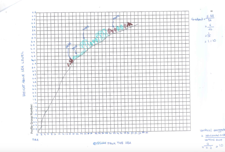
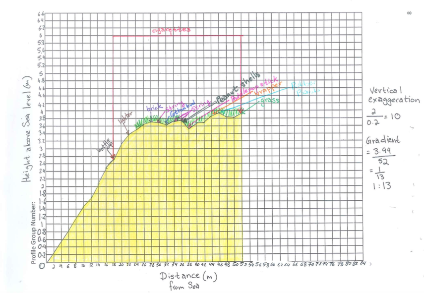
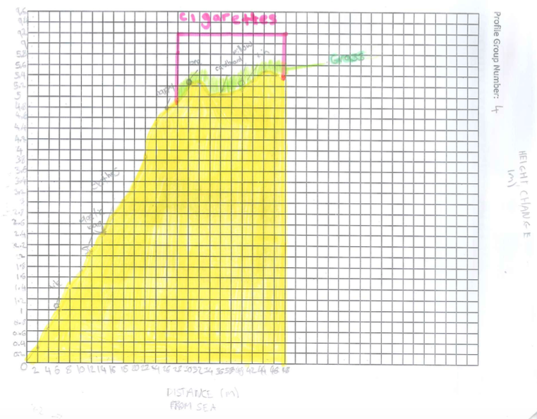
Beach profile 4 has a extremely longer stretch, probably due to sand being transported by longshore drift from beach profile 2&3. The height above sea level jumps from 3.7m to 5.4m above sea level, which proves that longshore drift has occurred . The slope from 0-3.8 m is very gradual and constant just like the previous profiles, but from 3.8m onwards there is a big jump and very prominent fluctuation with 2 peaks and a drop in between. In comparison to profile 3, there is a way shorter stretch of vegetation making it vulnerable to land erosion. Also probably due to longshore drift, this is the first profile with litter very close to the water. The water transports the litter and deposits it when the tide goes out. Another interesting thing is the fact only cigarettes occurred in vegetation areas. This is probably due to people usually sitting in the shade because the sun is hot.
|
Beach Profile 5 Analysis

|
Beach profile 5 shows us that there is a reoccurring pattern of an incline in the land towards the sea. This is visible in all the following profiles, but in beach profile 5 there is slightly more fluctuation. However, the slope is shorter at only 3.2m, likely due to water erosion. We can assume that there is a swash but it isn't that strong proven through the fact the land doesn't has a shorter and gradual incline. However, we know there is a swash because the sand is pushed up resulting in a dip where its furthest point reaches. After the jump there is a steady incline and a gradual decline, leading to a bigger drop, inching again and then a constant leading to the road. This is a sign of less human interaction in comparison to the previous beach profiles as it is getting further away from entertainment and recreational facilities. Since the graph is incomplete and does not show litter and vegetation, I can only presume that the vegetation starts at 26m due to the land beyond being rather consistent. I also thought that as we got further down the profiles the stretches would be longer due to the processes of longshore drift, but was obviously not the case.
|
Beach Profile 6 Analysis

|
Beach profile 6 has a very constant and gradual slope throughout the profile. The slope has a very gradual incline until it reaches 30m. After 30m the stretch is basically flat until 42m where there is a slight incline towards the road. This profile is a lot taller than beach profile 5, which can indicate the actions of longshore drift from 5 towards 6. Another interesting thing is, all the profiles have a dip but this profile doesn't and the reason why the slope could be gradual is because it is roughly the middle of the beach where most people would visit and through human interaction like walking it flattens the area. We can see human interaction through the litter collected being the most in this profile. The only picnickers on the beach were in this section as well. We can see that longshore drift is operating because compared to beach profile 5, beach profile 6 has a longer stretch, which was what I predicted would happen as we got further down towards the mangroves. Another thing that was surprising was that normally when vegetation occurs the land stays at a constant height, but in this case, it occurs on parts of the slope.
|
Beach Profile 7 Analysis

|
Beach profile 7 is quite significantly different , being 10m (height above sea level) less than profile 6. The gradual slope is shorter, stopping at 26m until there is a small decline and then a steady incline towards the road. We can tell by this profile that there is less human interaction due to the obvious signs of fluctuation.The beach does not increase in height as much as the sections closer to sea defense 1 as predicted and again. In comparison to beach profile 6, profile 7 has a more spread out and gradual incline. Just like the 6th profile, the vegetation occurred on the slope, where the beach is still inclining. We know vegetation starts where the waves reach the furthest point because longshore drift transports rubbish from the south of the beach (human impacted side) to north where the mangroves are. As the tide comes in (to its furthest point) it deposits the litter it has been carrying. The litter probably came from profile 6, where we can see had an abundance of litter. This proves that water does not com out very far, and in comparison the previous beach profiles vegetation starts at 19m and is 2.4m above sea level.
|
Beach Profile 8 Analysis

|
Beach profile 8 is evidently quite close to the mangroves as there is very little human interaction, shown by the fluctuation of the land inclining and declining. Beach profile 7 was 2.2m above sea level while profile 8 is 3.4 m above sea level. It also has a larger incline that profile 7 but a less than more of the other profiles. This profile is quite similar to beach profile 7 but instead of the constant steady incline in profile 7, in beach profile 8 the land declined, inclined and declined again. This has occurred due to less human interaction. This could be due to less humans interacting and since there is not a constant amount of people their foots steps would move the sand in certain areas. Behind the dip there are trees which is a stronger type of vegetation which keeps the soil tight and steady. The closer to the mangroves the sections were there was more sand due to the mangroves trapping sediment, which will build up in certain places, making the beach more uneven. It is also quite significantly taller than profile 7 possibly due to longshore drift transferring the sand towards the mangroves due to the direction of the prevailing wind. Also, as I have proved in profile 7, the location of where the litter is could have been caused by longshore drift bring them to where the water stops.
|
Beach Profile 9 Analysis

|
Beach profile 9 is directly next to the mangroves, proven through the fact that this beach profile is completely different from the rest of the beach profiles. You can see that the land 7.2m above sea level, significantly taller than all of the profiles, some being only half this. This is due to longshore drift transffering sand from section 1 to 9. This is due to more sand due to the mangroves trapping sediment, which will build up more sediment in certain places, making the beach more uneven. This section should have the least amount of human activity due to how far it is away from the human impacted area, it is unusual to see the amount of litter in the area. The litter, just like the sand would have been transferred from the opposite side of the beach due to longshore drift and moved into the mangrove area, where the litter is now stuck. Just like the previous graphs, a dip occurs at 22-26m and there is an extremly steep incline before the dip, which was not shown in other graphs. After the dip, there is another incline, but more gradual than the first. This graph is completely different due to the fact is 44m from sea, is 7m above sea level and has 2 slopes. This could have been caused by the mangroves further down protecting the area from longshore drift. We can also sea that longshore drift is operating due to the fact there is only litter in one concentrated area where the water would have deposited it in high tide. In general, the slope is quite gradual besides the fact there is a dip, which could indicate the presence of human interaction. Just like the vegetation in a few of the previous graphs, it continued to grow on the slope and was closer to the water. However, this time there were vines. Vines help protect wind and water erosion, and the dip may have been caused by the fact the dip area has no vegetation and has nothing to hold its shape.
|
